Uncover Montmartre’s art history with two free self-guided walks

For art enthusiasts and Montmartre strollers
Most people follow the crowds when they wander around the Montmartre area of Paris. That’s fine for many, it’s a great place to just stroll around. If you, like me, are an arts enthusiast and want to deepen your experience of being in Montmartre now, then you’ll need to find out a little about its art-history past.
Montmartre is famous for its artists but who were they and where exactly did they live and work? Where did Picasso get started? In which studio did Toulouse-Lautrec create his Moulin Rouge paintings and posters? Where did Theo and Vincent van Gogh live? Does Renoir’s famous Moulin de la Galette still exist ?
Follow my two free self-guided Montmartre artists’ studios walks and retrace the footsteps of the artists. See their workplaces and homes, stop where they ate and drank.
Clear maps guide you to home and studio, timelines connect painter with painting and place.
Montmartre has changed in the 150 or so years since the artists were here, but the street plan and some of the buildings remain. If you follow my routes, you will walk the same streets as they did.
I’ve done some art-history research and worked out a couple of circuits. The overall aim of the content is to intensify and amplify your experience of Montmartre. You have to bring holiday good-humor and some creative imagination.
As the streets of Montmartre unfold, allow the convergence of studio, artist, art and the information you will find in the site to deepen your feeling for the artistic legacy of this still unique place.
The Walks
The site features two walks, they take you to every known site associated with the artists in Montmartre.
Walk 1: upper Montmartre
Walk 1 covers artists’ studios, paintings and places in the upper Montmartre area around the hill of Montmartre.
Walk 2: lower Montmartre – Pigalle
Walk 2 visits sites associated with artists in the lower Montmartre – Pigalle area.

Disabled alternatives for the two walks
I offer alternative routes for wheelchair users for walk 1 and walk 2. Because of the steep inclines in walk 1 the disabled version of this walk is a different and longer route which incorporates the funicular link to get to the top of Montmartre. Below is the walk 1 alternative.

I have an extensive dedicated page on this disabled alternative of walk 1.
Walk 2 is less hilly and more accessible. The wheelchair alternative for the second walk only involves a short detour and then rejoins the original circuit. That short detour for walk 2 is indicated in blue below.

FAQs
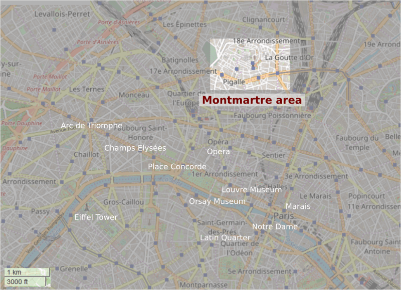
Where is Montmartre?
The Montmartre area is about 3.2 kilometres, about two miles, to the north of central Paris.
How do I get there?
Because of its hilly location and narrow streets, it is difficult to access Montmartre by public transport.
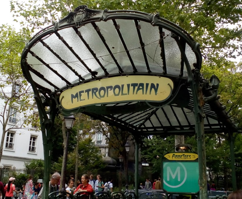
Both walks start at the Abbesses métro stop which is on line 12 of the Paris métro.
Line 12 can be accessed from central Paris at: Montparnasse Station, Place Concorde, the Madeleine or Saint-Lazare Station.
Emerging from the Abbesses métro straight into the busy Rue des Abbesses is one of the best ways to immediately catch the feel of contemporary Montmartre.
Bus number 80 is an alternative to the métro, stop Damrémont – Caulaincourt. You would then walk the length of Rue des Abbesses to get to the start of the routes at the Abbesses métro.
Is there a disabled version of the walks?
This is a variation of walk 1 upper Montmartre for accompanied wheelchair users. It tries—as far as is possible—to avoid the worst of Montmartre’s steepest parts. Please see above for the maps, the disabled alternative routes are shown in blue.
Skirting round steps and avoiding the stiffer gradients makes for a longer and less direct route.
Walk 2 lower Montmartre – Pigalle could be followed by an accompanied disabled person almost in its entirety, there is just one minor detour at the beginning of the walk—to avoid steps.
You will find the dedicated directions and maps for the walk 1 alternative disabled route on the wheelchair route page.
I am not disabled, so it is difficult for me to judge how appropriate my circuit is. Because Montmartre is hilly and the roads are cobbled, I would say that non-motorised-wheelchair users would have to be accompanied by someone strong enough to be able to push uphill. I hope that it is a viable alternative.

How long are the walks?
Walk 1, upper Montmartre is 2.7 kilometres or 1.67 miles long. The route traces roughly a figure of eight. All of the important artistic sites of upper Montmartre are covered. Allow about a couple of hours to complete the circuit.
The wheelchair alternative of walk 1 upper Montmartre is considerably longer at 4.15 kilometres or 2.57 miles; this is because it follows a quite different track to avoid steep inclines and stairs.
Walk 2, lower Montmartre – Pigalle is 2,2 kilometres or 1,4 miles long.
The wheelchair alternative of walk 2 lower Montmartre – Pigalle is also 2.2 kilometres or 1.4 miles.
How difficult are the walks?
The upper Montmartre circuit is hilly with some steep sections and cobbles.

Walk 1 involves some climbing and there are some short steep sections. Most of the route is over cobbles. You climb about 300 feet. The combination of steepness and cobbles make it more challenging than its 2.7 kilometres or 1.67 mile length would suggest.
The disabled alternative route for walk 1 incorporates the funicular link to get to the top of Montmartre but also runs over cobbles and includes some moderate inclines.
No matter which way you approach it the upper Montmartre area remains hilly and involves an effort.
Walk 2 is less challenging; there are slopes but they are more gradual.
Can I visit any of the sites?
Many of the points visited on both walks are now private residences or workplaces and cannot be visited. Please be discreet when taking photographs and not disturb the people who live or work there.
The numbered sites on the tour that can be visited are:
Walk 1
Point 1 Père Azon – Le Relais de la Butte, a restaurant
Point 4 Le Moulin de la Galette, a restaurant
Point 6 La Maison Rose, a restaurant
Point 8 Le Lapin Agile, a cabaret
Point 9 The Montmartre Museum
Point 13 Studio 28, a cinema
Point 14 Métro Abbesses, the Art Nouveau public entrance to the Paris métro line 12.
Walk 2
Point 8 Moulin, Rouge a cabaret show.
Which of the two walks is the more scenic?
Walk 1, the upper Montmartre circuit, is the most scenic. It takes you close to, but does not include, the Sacre Coeur church.
Walk 2 the lower Montmartre – Pigalle route features Edgar Degas and Henri de Toulouse-Lautrec. I look in detail at many of their major works. This is a less scenic walk—although we do pass the Moulin Rouge—but worth the detour especially if you like Lautrec and Degas and want to see where they lived and worked.

Also in walk 2 we forget about painters for a moment and skip forward a generation to take in the 1920s Paris jazz scene because it happened in this area too.
Where do the walks start?
Both walks start at the Abbesses métro which is the best station for getting to Montmartre.
I want to find out about the history of Montmartre and the art history of the period, where do I find that?
The upper Montmartre circuit can be approached just as a pleasant walk featuring interesting and picturesque sites.
Those of you interested in history and art history can browse the more detailed contextual information that I have put together. These include: the History and culture of Montmartre, the Commune, the Salon system, influences on Picasso’s Demoiselles d’Avignon. I look briefly at late 19th century gender stereotypes in French society on my working women and bourgeois men page.
Walk 2 features some extended appreciation of the work of Degas, Toulouse-Lautrec as well as Picasso and Braque’s early cubist works.
Most of this more detailed material reflects conventional views from authoritative sources. I do also throw in some personal interpretation because that is part of the fun of looking at art.
Montmartre is small but all of the works I feature were created here by artists who lived and worked in this pressure-cooker art hotspot. Modern Montmartre lives on their legacy. They walked these very streets; so don’t follow the crowds, follow in their footsteps and catch their spirit.

All photographs © David Macmillan.